DIGITAL PHOTOGRAMMETRY

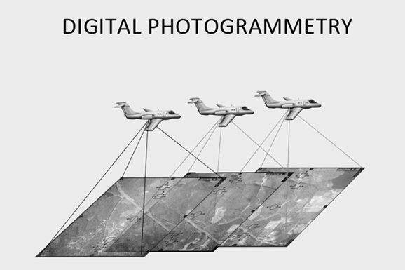
Photogrammetry, as its name implies, is a 3-dimensional coordinate measuring technique that uses photographs as the fundamental medium for metrology (or measurement). The fundamental principle used by Photogrammetry is triangulation or more specifically called Aerial Triangulation. By taking photographs from at least two different locations, so-called “lines of sight” can be developed from each camera to points on the object. These lines of sight (sometimes called rays owing to their optical nature) are mathematically intersected to produce the 3-dimensional coordinates of the points of interest.

By the use of digital photogrammetry, mapping, map updating and 3D city models are processed. At PTW, the focus areas in digital photogrammetry are direct georeferencing, the use of digital photogrammetric cameras in mapping, radiometric calibration of digital aerial images, extraction of building outlines and integration of laser scanning and photogrammetry.

Digital Photogrammetry

Digital Photogrammetry Services

Aerial Triangulation

Digital Aerial Triangulation (DAT) is an extremely important phase in the Photogrammetry process. Aero Triangulation is the process of precisely orienting Aerial or satellite imagery to the control system defined for a project.

Digital Elevation Model Creation

A digital elevation model is a 3D representation of the terrain elevations found on the earth’s surface. DEMs are generated from variably-spaced LiDAR ground points, or they can be created using a raster grid.

DTM & DSM Generation and Editing

DTM (Digital Terrain model ) can be described as a three dimensional representation of a terrain surface consisting of X, Y, Z coordinates stored in digital form and It includes not only Terrain elevation also natural features such as rivers, ridge lines, etc. Natural features are called break lines. DSM (Digital Surface Model) represents the MSL elevations of the reflective surfaces of trees, buildings, and other features elevated above the “Bare Earth”.

Ortho Photo Creation and Rectification

Utility Mapping is a special class of GIS applications for managing information about public utilities such as water pipes, sewerage, telephone, electricity, and gas networks.

Topographic Map Creation

A topographic map creation is a detailed, accurate graphic representation of features that appear on the Earth’s surface which includes roads and railways, provincial and national parks, place names, municipal and township boundaries, lots and concessions and lakes and rivers, falls, rapids and rocks, wooded areas, wetlands.

Planimetric Feature Extraction

Planimetric feature extraction involves the creation of maps that show only the horizontal position of features on the Earths’ surface, revealing geographic objects, natural and cultural physical features, and entities without topographic properties.