REMOTE SENSING & IMAGE PROCESSING

We provide advanced image analysis and remote sensing services by means of top-grade satellite imaging methods. Our GIS professionals are well acquainted with an array of satellite data products and always go for the most up-to-date geographic information system and digital image processing software packages.

We provide a complete range of services to help clients obtain the best type of Digital Imagery, whether it is Aerial Photography or Satellite Imagery. We can deliver the results quickly from desktop, web or mobile devices-making imagery more accessible, more powerful and easier to use across all types of industries and applications including Mineral Exploration, Forestry, Land-Use Management, Environmental Monitoring and Assessment.

Remote Sensing

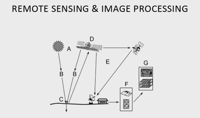
Remote Sensing and Image Processing Services

Land Use & Management

Land Use and Management focuses on land and on the way land is used for production, conservation and aesthetic reasons.

Image Interpretation and Classification

Image interpretation is an important supporting component. In image interpretation following roles in a satellite-mapping are :
A) High-resolution photos provide an efficient means of providing training site information for image classification.
B) During intermediate assessment phases, they are the good tool for verification of a classification.
C) Following field verification, photos are invaluable for reclassification and editing.
D) During the final accuracy assessment of image classification, aerial photography provides an efficient means, in some cases the only means, of determining classification accuracy.

Common classification procedures can be broken down into two broad subdivisions based on the method used:
A) Unsupervised image classification.
B) Supervised image classification.
C) Object-based image analysis

Landscapes and Soil Resources Assessment

Soil resources across a wide range of scientific disciplines and application domains. This is the direct benefit of environmental professionals, who employ imaging and geospatial information for improved understanding, management, and monitoring of soil resources.

Forest Ecosystem Analysis

We are using a geographic information system (GIS) to understand and integrate forest processes at landscape to regional spatial scales.

Satellite Image Rectification

Rectification is a process of geometrically correcting an image so that it can be represented on a planar surface, conform to other images or conform to a map. That is, it is the process by which geometry of an image is made Plan metric.

Satellite Image Tiling and Color Balancing

It is having four reflectance bands i.e. NIR, RED, GREEN and BLUE. The datasets are available in 10 degree grid size covering India and adjoining countries in almost 20 tiles.

Image Enhancement

Image Enhancement services cater to professional photo editing agencies, digital photographers, photo studios, online art galleries, e-book editors and publishers, webmasters and web designers, real estate agents, catalog publishers, and online stores.

Analysis for Geosciences & Data Processing

With the development of new software technologies true integration, processing and visualization of multivariate geochemical, geophysical and geological data is now possible. A variety of data from different sources were quickly imported, processed and visualized together.

Urban and Regional Planning

Planning as a general activity is the making of an orderly sequence of action that will lead to the achievement of a stated goals. Urban and regional planning talk about planning the economy to minimize the swings of boom and slump and to reduce the misery of unemployment.

Urban Resources and Facilities Analysis

The aims are first to evaluate the accessibility of various urban resources using spatial data analysis in geographical information systems and then to develop an indicator of the accessibility of services and facilities for each public housing project using multivariate data analysis.

Urban Environment Studies and Growth Analysis

The conversion of Earth’s land surface to urban uses is one of the most irreversible human impacts on the global biosphere. It hastens the loss of highly productive farmland, affects energy demand, alters the climate, modifies hydrologic and biogeochemical cycles, fragments habitats, and reduces biodiversity.